Surveyors
Advertisement
WinDeed v.5.7.36.2
WinDeed is the tool of choice for law firms, estate agencies, credit bureaus, valuers, surveyors, conveyancers, and other professionals involved in searching for information in the Deeds Office, Companies and Intellectual Property Registration Office
Advertisement
RD8000 SurveyCERT v.1.0
RD8000 SurveyCERT makes cable & pipe mapping easier for surveyors in the field. Survey data may either be viewed in real time or be saved within the RD8000 to be reviewed later. An useful software that you can easy get it on your computers.
PCM+ SurveyCERT v.1.0.10
PCM SurveyCERT makes pipe mapping easier for surveyors in the field. Survey data may either be viewed in real time or be saved within the PCM to be reviewed later.
Copan for PocketPC v.1.0.7
Copan for Pocket PC is a very functional and easy-to-use geomatics engineering tool for computing and managing plane surveying and mapping coordinates. It does numerous coordinate geometry (COGO) calculations, processes and adjusts raw field survey
Copan for Windows v.10 9
Copan for Windows desktop/netbook is a very functional and easy-to-use geomatics engineering tool for computing and managing plane land surveying and mapping coordinates. It does numerous coordinate geometry (COGO) calculations, processes and
Copan for Mobile v.1.0.7
Copan for Mobile 6 is a very functional and easy-to-use geomatics engineering tool for computing and managing plane surveying and mapping coordinates. It does numerous coordinate geometry (COGO) calculations, processes and adjusts raw field survey
CopanMobile for PalmOS v.1.0.3
CopanMobile for Palm OS is a very functional and easy-to-use geomatics engineering tool for computing and managing plane surveying and mapping coordinates. It does numerous coordinate geometry (COGO) calculations,
CopanMobile for PocketPC v.1.0.2
CopanMobile for Pocket PC is a very functional and easy-to-use geomatics engineering tool for computing and managing plane surveying and mapping coordinates. It does numerous coordinate geometry (COGO) calculations,
PROMATECT 50 HOTELS v.1.0
PROMATECT® 50: HOTELS - a guide to lightweight construction.
IPJC v.0.5
iPJC is an easy-to-use record keeping system for the land surveying industry. It allows your staff to securely store, retrieve and cross-reference all of your company's survey database records -- of estimates, plans,
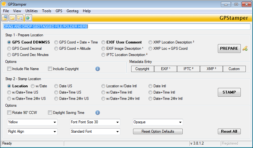
GPStamper v.3.8.3.0
Automatically extract from a geotagged imageOCOs metadata, and then visually imprint (stamp), the GPS position, location description, altitude, date, date and time, or any combination of these or any other file metadata, onto a photo with no loss in